-
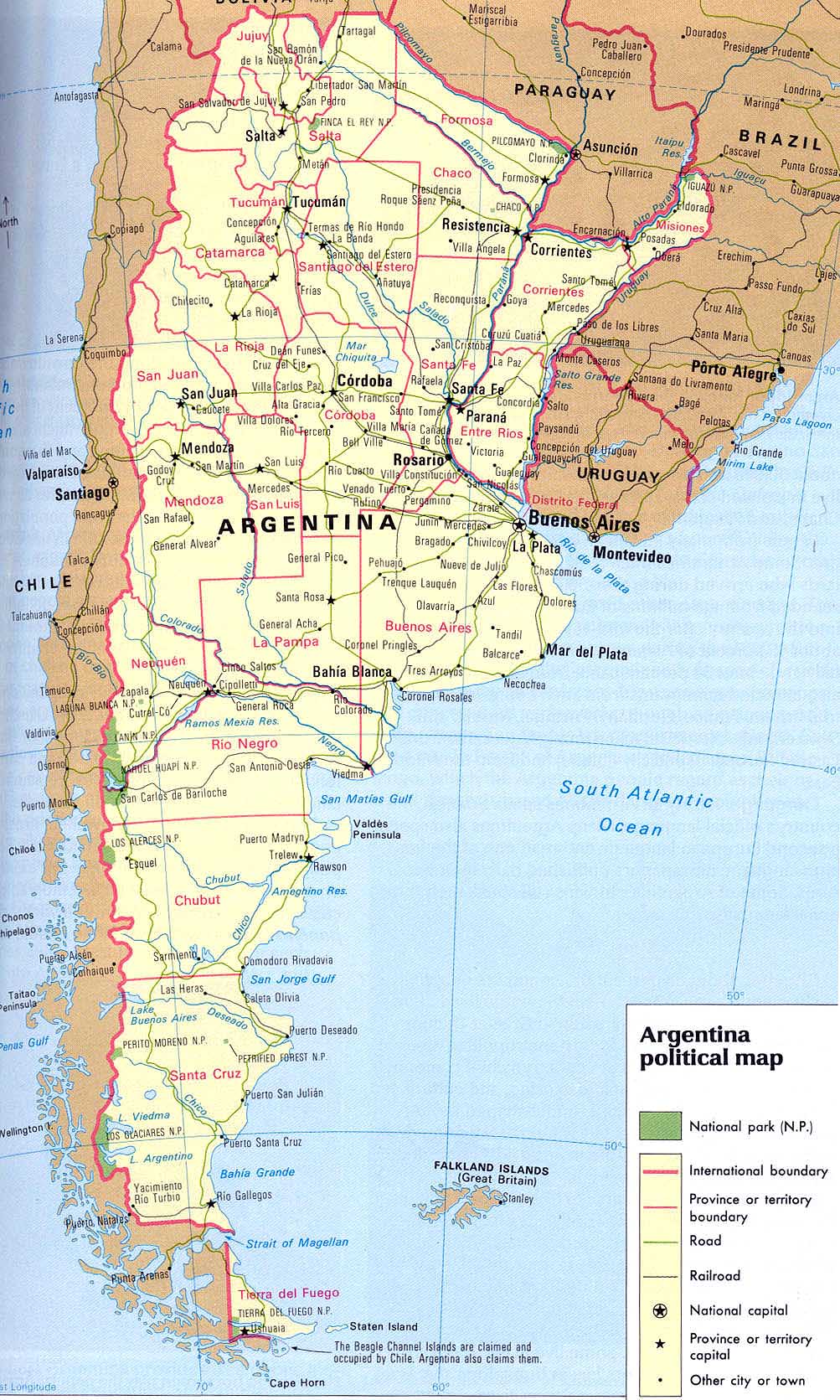
- Argentina Map
|
-
-
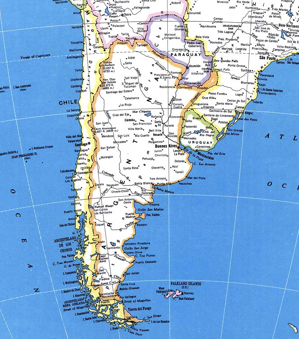
- Map from southern
South America
|
|
-
|
- latest picture:
July 17, 1988
|
-
-
|
-
-
|
-
-

|
-
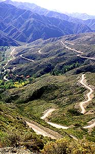
800 We are rolling on the Ruta RN40
- through the
endless Argentine Pampa
- towards the South
|
-
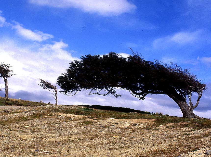
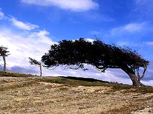
801 The trees are formed by the
- power of the
eternal strong winds
- in the Argentine pampa
|
-
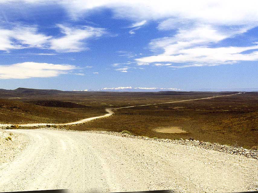
802 The legendary Ruta
RN40 south of
- Perito Moreno runs through the vastness of
- the
Argentine Pampa. 1987 everything was
- still gravel and lonely û
average 1 car/day!
|
-
|
-
-
|
-
-
|
-
-
|
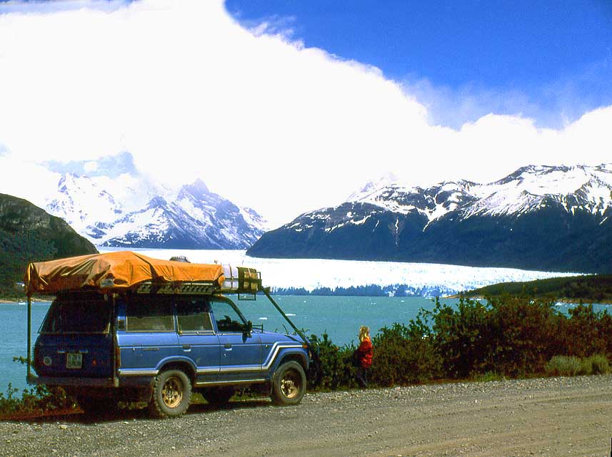
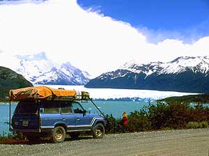
- The Perito Moreno Glacier, 47 ms [76km] west of El Calafate at
Lago Argentino in the province of Santa Cruz
- is one of Argentina's
most important tourist attractions besides the Iguaz· waterfalls.
- It
covers 96¢ square miles [250km▓] of ice formation, is 18¢ ms [30 km]
long, 3 ms [5 km] wide and 560 ft. [170m] thick.
- The name should not
be confused with the same-named village (-46.58314 -70.92747)
near Lago Buenos Aires, 477 miles [768km] north,
- nor with the
National Park of the same name (-47.83967 -72.04244) near Lago
Belgrano, 376 ms [605km] north
|
-
803 Photo stop of Perito Moreno Glacier
- with
still snow-covered Andes peaks, about
- 4¢ ms [7km] before the
parking lot. It is
- one of the few glaciers worldwide that still
- grows û about 6¢ ft. [2m] per day
|
-
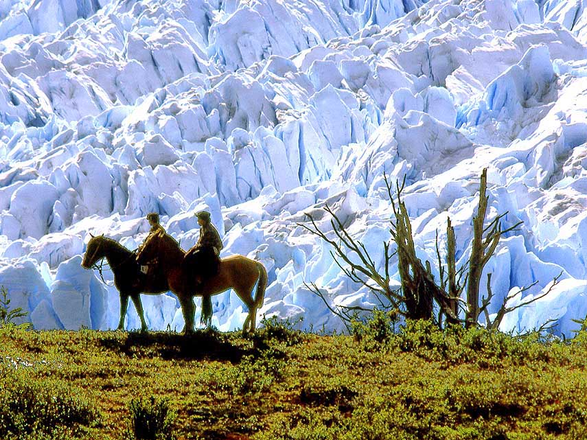
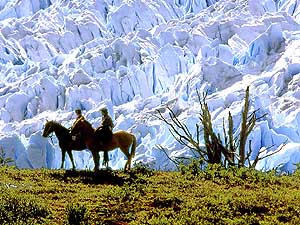
804 On horseback along the
- Perito Moreno glacier
wall.
- It formed during the last ice age and
- is an incredible 18'000
years old!
|
-
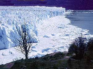
805 Glacier front of the
Perito Moreno
- Glacier. The glacier calves constantly and
- ice floes
swim in the crystal clear lake
|
-
|
-
-
|
-
-

|
-
-
|
-
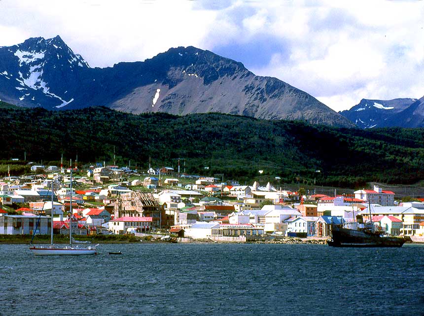
806 On 12/30/1986 we reach the southern
- end of
the Panamericana in Ushuaia on
- Tierra del Fuego û the most southerly
town
- on earth û where we celebrate New Year
|
-
807 Ushuaia/Tierra del Fuego, the
- southernmost
city in the world, also called
- "end of the worldö. On the date of
our visit
- in 1986, Ushuaia had about 8'000 to 8'500
- people û today
about 78'000!
|
-
808 A flock of sheep,
pressed close
- together against the cold and wind in San
- Sebastian/Tierra del Fuego. About 40% of
- all Argentinean sheep are
bred in Patagonia
|
-
|
-
|
-
-
|
-
|
-
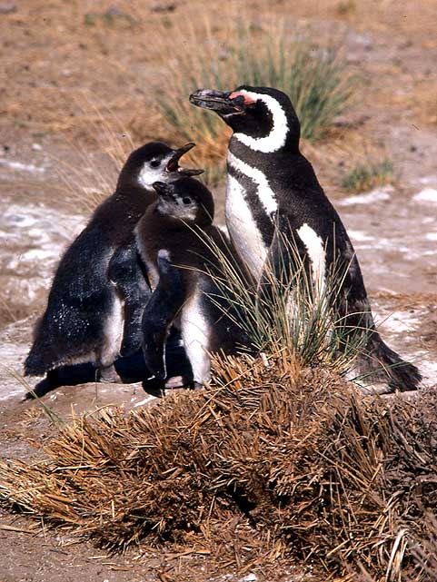
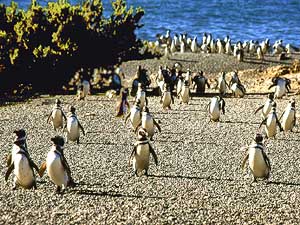
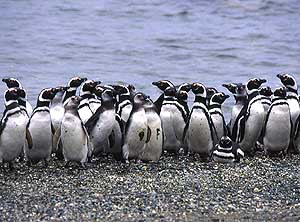
809 So cute: Magellanic penguins
- (Spheniscus
magellanicus) step out
- from the sea in Cabo Dos BahÝas/Chubut
- Province, about 180ms [300km]
- northeast of Comodoro Rivadavia à..
|
-
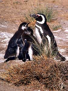
810 à.. a small family à..
|
-
811 à.. and Magellanic
penguins
- in rank and file
|
-
|
-
|
-
-
|
-
|
-
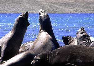
812 Sea lions (Otaria flavescens) at
- Puerto
Pirßmides on the PenÝnsula ValdÚs.
- The males weigh about 770 lb.
[350kg]
- and the females 330 lb. [150kg]
|
-
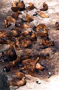
813 A small Patagonian sea lion colony
- (Otaria
flavescens) on the PenÝnsula ValdÚs.
- Seals are considered social. A
harem can
- consist from 2 up to 130 females
|
-
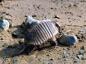
814 Big hairy armadillo
(Chaetophractus
- villosus): It is one of the largest and most
- numerous armadillos in South America
|
-
|
-
|
-
-
|
-
|
-
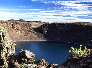
815 The deep blue crater lake ôLaguna
- Azulö (Blue
Lagoon û -52.07490 -69.58155)
- of an extinct volcano, 7ms [11km]
- north of the Argentina-Chile border
|
-
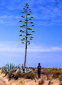
816 Emil in front of a blooming Agave:
- It blooms
only once in its life and after the
- fruit ripens it dies. The
inflorescence (stem)
- can grow up to 40 ft. [12m]
|
-
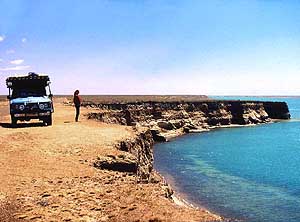
817 Wild Atlantic Coast on
the
- Valdez Peninsula
|
-
|
-
|
-
-
|
-
|
-
818 Beautiful wild landscape along
- Ruta RN25
across Argentina from
- Trelew in the east to Tecka in the
- west, 16
miles south of Esquel
|
-
819 Impressive waterfalls, called
- ôGarganta del
Diabloö (-41.19458 -71.83175)
- in different levels at 11'453 ft.
[3'491m]
- tall Cerro Tronador, about 50ms [80km]
- west from Bariloche
|
-
820 Our LandCruiser in
front of
- Cerro Tronador, an extinct volcano.
- With its 11'453 ft.
[3'491m] it is
- the highest mountain in Patagonia
|
-
|
-

|
-
-
|
-

|
-
821 Panoramic view of the Llao Llao
- Peninsula
with the luxury 5* Hotel Llao
- Llao northwest of San Carlos de
Bariloche
- and with the lakes Moreno Oeste (in the
- front) and Nahuel
Huapi (background)
|
-
822 Glittering lakes (from front to west)
- Hualahue, Steffen and MartÝn, 37ms [60km]
- south of Bariloche with
the backdrop of the
- snow covered Andes peaks
|
-
823 Valley ôEncantadoö on
the
- Limay River, about 38¢ms [62km]
- from Bariloche along the Ruta
RN237
- û a natural paradise surrounded
- by bizarre mountain peaks
|
-
|
-
|
-
-
|
|
-
824 Morning mood on 2/2/1987 on
- our night spot at
the lake Lago Traful
|
-
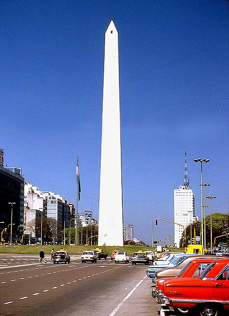
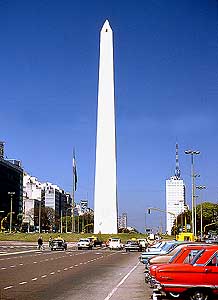
825 The 235 ft. [71.5m] high Obelisk
- in Buenos
Aires at the Plaza de la
- Rep·blica û a national historic
- monument û
was built in 1936. It can
- be called the ôcenterö of Buenos Aires
|
-
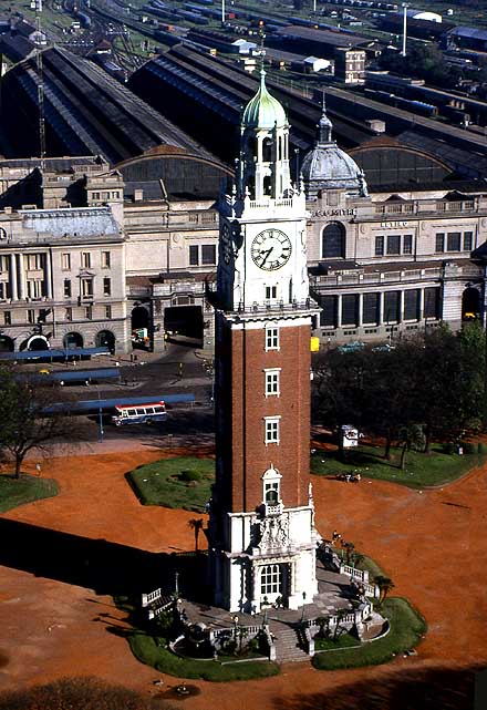
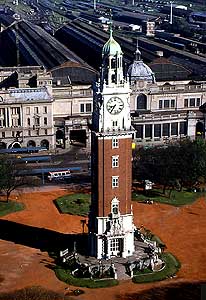
826 ôTorre Monumentalö,
until 1982 û
- the Falkland war û called ôTorre de los
- Inglesesö
(=English) in Buenos Aires at the
- railway station ôRetiro-Mitreö. It
is 248 ft.
- [75.5m] and eight stories high. The building
- was
inaugurated on 24.5.1916
|
-
|
-
-
|
-
-
|
-
-
|
-
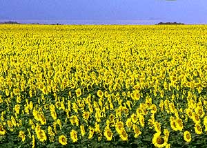
827 Brightens every gloomy mood:
- A field of
sunflowers (Helianthus annuus)
- as far as the eye can see. Sunflowers
are
- very dependent on light. The more light,
- the bigger the flowers
|
-
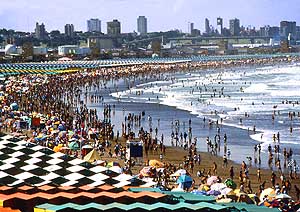
828 ôMar del Plataö, about 630'000
- people, is the
most famous beach resort
- in Argentina. It attracts in the high
season
- 7 millions of sun-seekers à..
|
-
829 ..... no matter how
crowded the
- beach is, the main thing is to have fun
|
-
|
-
-
|
-
-

|
-
-
|
-
830 Camping at ôEl Palmar National
- Parkö,
province Entre RÝos, between Yatay
- palms (Butia yatay). In the
background
- ôRÝo Los Lorosö. The park was founded
- in 1966 to protect
this palm species à..
|
-
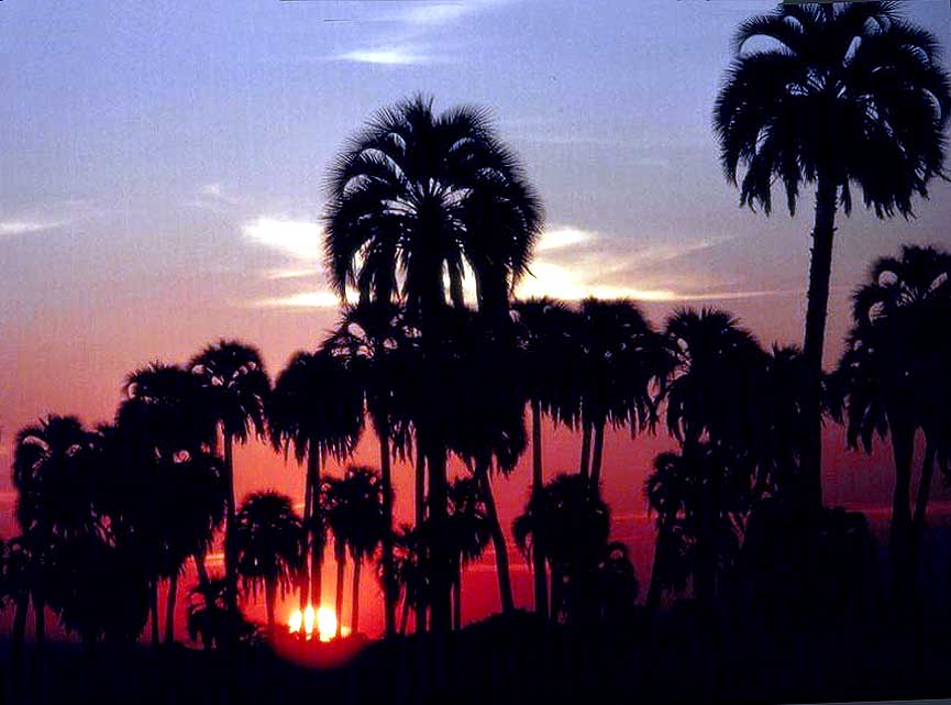
831 à.. palm trees rise against
- the sky colored
red by the sunset
|
-
832 Our LandCruiser
surrounded by
- white wind- and water eroded rock
- formations in the
ôValle de la Lunaö
- (moonscape) in the province San Juan,
- today named
ôIschigualasto Prov. Parkö
|
-
|
-
|
-
-
|
|
-
833 Our Landcruiser along the magnificent
- Cerro
Alcßzar with its unique bizarre rock
- towers about 12¢ms [20km] south
of
- Calingasta on the Ruta RN149 in the
- province of San Juan
|
-
834 The winding ascent to the
- ôCruz de Paramilloö
Pass, Ruta RP52,
- from Mendoza to Uspallata
|
-
835 The abandoned spa building
at
- ôPuente del Incaö, altitude of 8'990 ft.
- [2'740m]
en route to the Bermejo Pass/
- Mendoza prov. û an Andean pass with
a
- tunnel option between Argentina and Chile
|
-
|
-
-

|
-
|
-
-
|
-
836 A photo stop at the ôChristo
- Redentorö
Monument on the Bermejo
- Pass at 12'598 ft. [3'840m] altitude. The
- approximately 7ms [11km] shorter tunnel
- option climbs only to 10'571
ft. [3'222m]
|
-
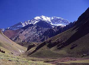
837 View from ôFin Sendero de la
- Lagunaö, almost
2¢ms [4km] from Ruta
- RN7, to the 22'837 ft. [6'961m] high
- Aconcagua,
the highest mountain
- in South America
|
-
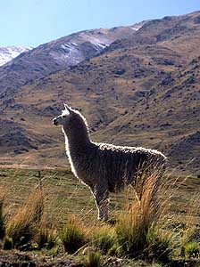
838 A lama (Lama glama) in
the
- high mountains of Argentina.
- Lamas feed on grasses, shrubs,
- lichens, leaves and mushrooms
|
-
|
-
-

|
-
-

|
-
-

|
-
839 On the gravel road through the
- highlands of
the 15'505 ft. [4'726m] high
- San Francisco Pass û for us the most
- beautiful crossing of the Andes from the
- Atacama Region of Chile to
the province
- of Catamarca in Argentina à..
|
-
840 ..... the grass buds glow
- golden in the sun
|
-
841 Dramatic landscape on
the
- gravel road as we descend from the
- highland of the San Francisco
Pass
- on Ruta RN60 to the
- Catamarca province
|
-
|
-
-
|
-
-
|
-
-
|
-
842 Quiet night spot in the protecting
- forest on
the way to Tucumßn, to be
- precise ôSan Miguel de Tucumßnö û
- the
capital
|
-
843 Gauchos û the skilled horsemen û
- guide their
sheeps through a dusty path to a
- new destination û here in Salta.
Gauchos are
- known for their pride, bravery and loyalty
|
-
844 Ride through the
magnificent
- sandstone formations of the
- ôQuebrada de las Flechasö
- between Cafayate and Cachi
|
-
|
-
-
|
-
-
|
-
-
|
-
845 Liliana poses with our LandCruiser
- in front
of the natural rock formation
- ôthe obeliskö in ôQuebrada del RÝo de
las
- Conchasö, 15 miles northeast of Cafayate
- along Ruta RN68
|
-
846 Along the Cafayate-Salta stretch
- (Ruta RN68 û
ôQuebrada RÝo de las
- Conchasö) eroded colorful hills
- frame the road
à..
|
-
847 à.. Illuminated by the
sun,
- the red sandstone wall glows particularly
- intensive, also Ruta
RN68 û
- ôQuebrada RÝo de las Conchasö
|
-
|
-
-
|
-
|
-
-
|
-
848 A giant beauty of a Saguaro cactus
- (Echinopsis terscheckii), which makes Emil
- look insignificant. It
can grow up to 40 ft.
- [12m]; Life time 250-300 years
|
-
849 The unique, varied and colourful
- landscape
along the mountain road Ruta
- RN51 from Salta to San Antonio de los
- Cobres in the ôQuebrada del Toroö à..
|
-
850 à.. with pinnacles and
Saguaro
- cacti side by side (here also in the
- ôQuebrada del Toroö)
|
-
|
-
-
|
-
-
|
-
-

|
-
851 The small neat church of the little
- village
of El Alfarcito on an altitude of
- 9'186 ft. [2'800m] in the
ôQuebrada del
- Toroö in the Salta province along
- Ruta RN51
|
-
852 Our LandCruiser is rolling through
- the
beautiful Andes desert at 3Æ775m
- [12Æ385 ft] altitude near San
Antonio de
- los Cobres in the Salta province
|
-
853 The ôTren a las Nubesö
(train to the
- clouds) crosses the 735 ft. [224m] long,
- 207 ft. [63m]
high ôLa Polvorillaö viaduct,
- at altitude 13779
ft.[4200m]
11ms[17¢km]
- west of San Antonio de los Cobres
along the
legendary Ruta RN40
|
-
|
-
-
|
-
-
|
-
-
|
-
854 Zigzag mountain pass Ruta RP16
- (today RN52)
from the ôPuna de Atacamaö
- (Atacama Plateau) to Purmamarca in the
- province of Jujuy
|
-
855 The highlands of Argentina (Puna)
- are home to
lamas (Lama glama)
|
-
856 Bolivian women in La
Quiaca/Jujuy
- at the Bolivian border. The typical dress of
- the
"cholitas" (women) consists of 5-6
- petticoats, a shawl and a typical
hat
|
-
|
-
-
|
-
-
|
-
-
|
-
857 Clay church of Pozuelos in the
- province of
Jujuy in North Argentina
|
-
858 The ruins of the Jesuit Mission of
- ôSan
Ignacio MinÝö, 40ms [64km] northeast
- of Posadas in the province of
Misiones, are
- part of the Unesco World Heritage
|
-
859 The water vapour
indicates the
- power of the nearby Iguaz· Falls, where
- in the average
62'000 cu ft./s [1'756m│]
- of water fall down the river every second
- (rainy season: 230'000 cu ft./s [6'500m│/s]
|
-
|
-
|
-
-
|
-
|
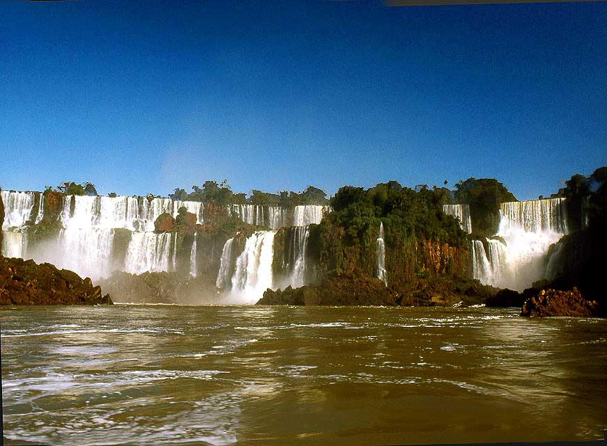
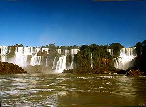
- The natural spectacle of the Iguaz· waterfalls, which are part of
the Unesco World Heritage: They are located in the country triangle
of
- Argentina (= Puerto Iguaz· ▒ 100'000 people), Brazil (= Foz do
Iguaþu ▒ 260'000 people) and 12¢ miles [20km] away Paraguay
- (=
Presidente Franco ▒ 100'000 people + Ciudad del Este ▒ 310'000
people), and consist of between 150 and 275 falls depending on
|
-
860 A whole series of
waterfalls rush
- into the depths. It shows the gigantic size
- of the
Iguaz· Falls
|
-
861 View of the thunderous
- ôDevil's Throatö
(ôGarganta del Diabloö)
- of the Iguaz· waterfalls
|
-
862 Gigantic view of the
Iguaz·
- waterfalls and its protected jungle.
- At the highest point the
water rushes
- up to 269 ft. [82m] into the depth
|
-
|
-
Next website from
southern South America:
- Paraguay
Part 1
|
- The African trip
2013-16:
- CapeVerde: Santiago/Praia
part 1 û November18th to December 13th, 2013
- CapeVerde: Fogo
û Dezember13th to 23rd, 2013
- CapeVerde: Brava
û December 23rd to 26th, 2013
- Cape Verde: Santiago/Praia
part 2 û December 26th, 2013 to February 28th, 2014
- Cape Verde: SÒo Nicolau û February
28th to March 13th, 2014
- Cape Verde: SÒo Vicente/Mindelo part 1
û March 13th to 20th, 2014
- Cape
Verde: Santo AntÒo/Eastern side part 1 û
March 20th to April 7th, 2014
- Cape
Verde: Santo AntÒo/Western side part 2 û
April 7th to 10th, 2014
- Cape
Verde: SÒo Vicente/Mindelo part 2 û
April 10th to 29th, 2014
-
Namibia Part 1 û
from Walvis Bay to Windhoek
- Angola Part 1
û
September 26th to October 4th, 2014
- Angola Part 2 û
October 4th to 22nd, 2014
-
Namibia Part 2 û
from Windhoek to the Angolan border, back again and on to
South Africa
-
South Africa
Part 1 û
from Namibia border to Capetown û
January 22nd to February 23rd, 2015
- 3rd Major Repair of our
LandCruiser FJ60 - 1982 (due to two broken sideshafts)
-
South Africa Part 2 û from Capetown to Tsitsikamma National Park û
February 24th to March 13th, 2015
- South Africa Part 3 û from
Addo National Park to the Lesotho border û March
13th to April 7th, 2015
-
Lesotho û April 7th to 15th, 2015
-
South Africa Part 4
û from the Lesotho to the Swaziland border û
April 15th to 23rd, 2015
-
Swaziland û April 23rd to 28th,
2015
-
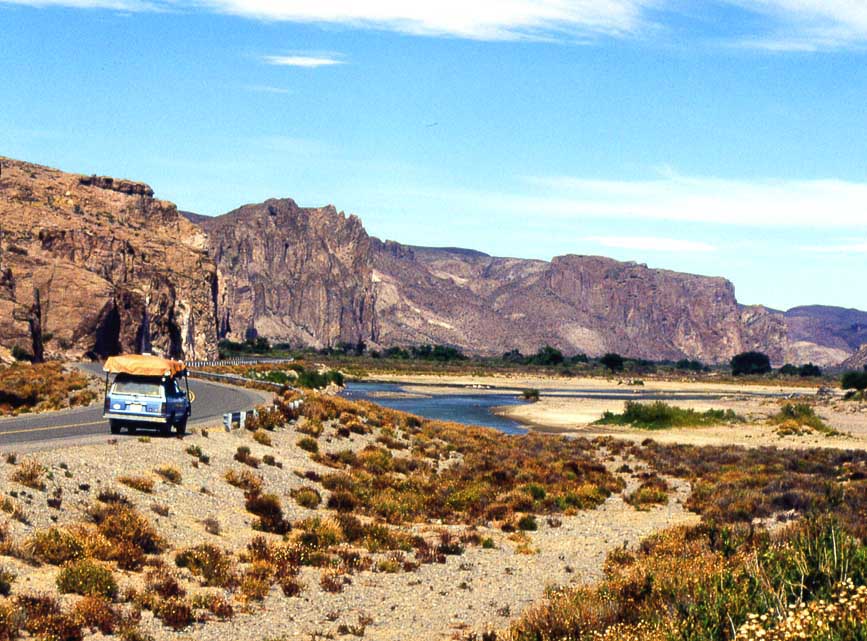
South Africa Part 5
û from the Swaziland to the Botswana border
û April 28th to May 15th, 2015
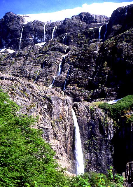
-
Botswana
-
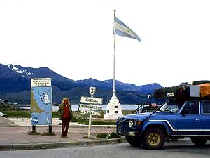
Zimbabwe
-
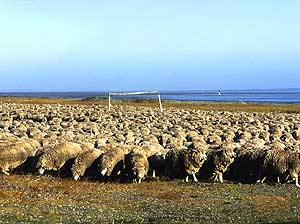
Mozambique
-
Malawi
-
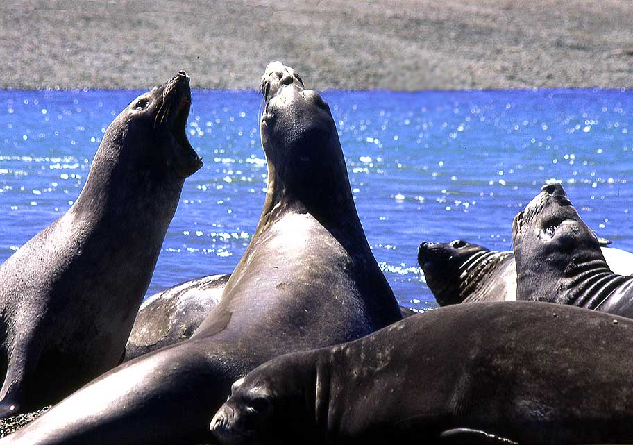
Armed Robbery in Malawi on July
31st/August 1st, 2015
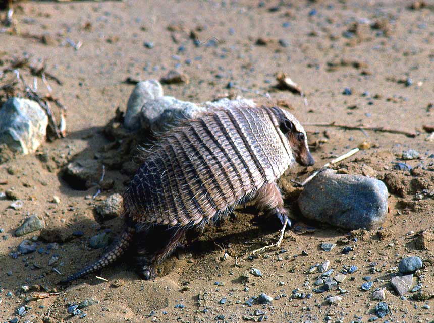
-
Tanzania
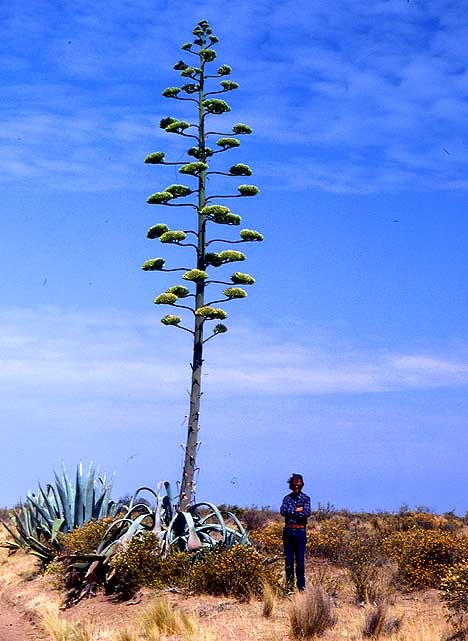
-
Kenya
-
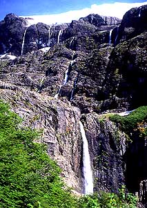
Ethiopia Part 1 û from Kenya to
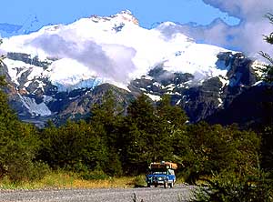
Djibouti –
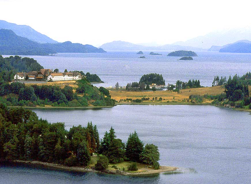
October 25th to November 18th, 2015
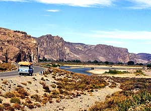
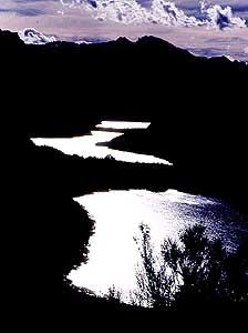
-
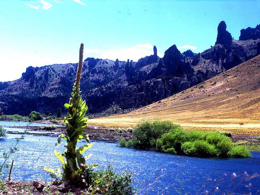
Djibouti –
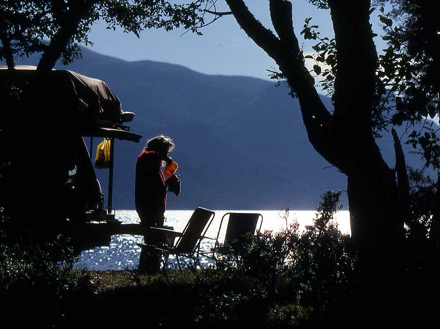
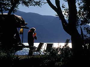
October 18th to 27th, 2015
-
Ethiopia Part 2 –
from
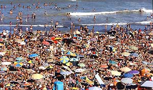
Djibouti to
Sudan –
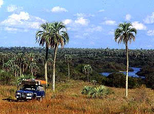
November 27th to December 9th, 2015
- Sudan –
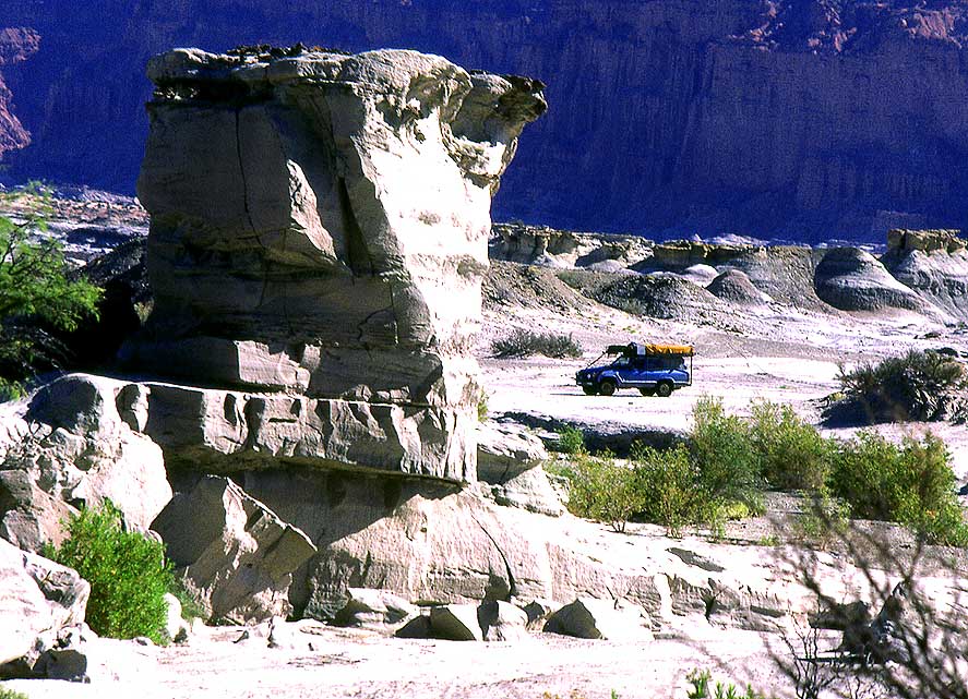
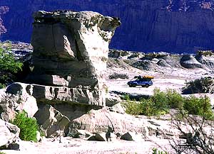
December 9th, 2015 to January 8th, 2016
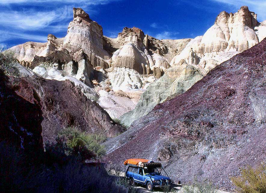
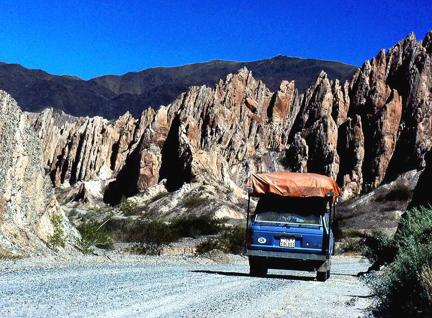
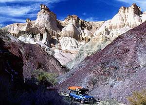
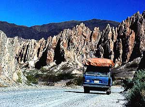
-
The continuation in Asia 2016-18:
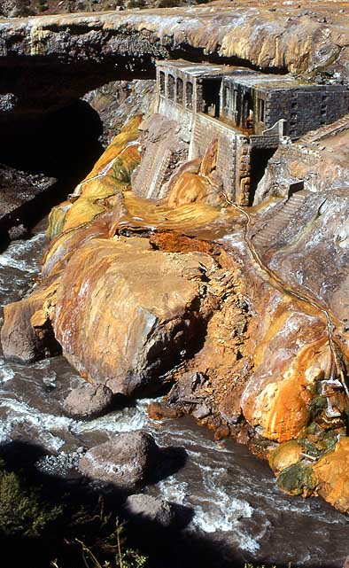
-
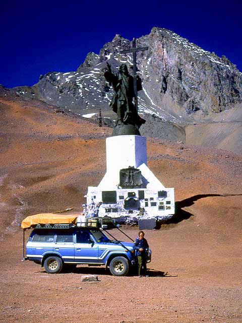
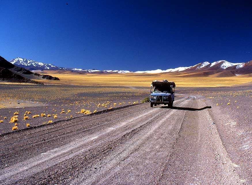
Saudi Arabia – January 9th
to 12th, 2016
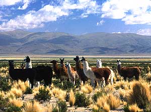
- United Arab Emirates – January
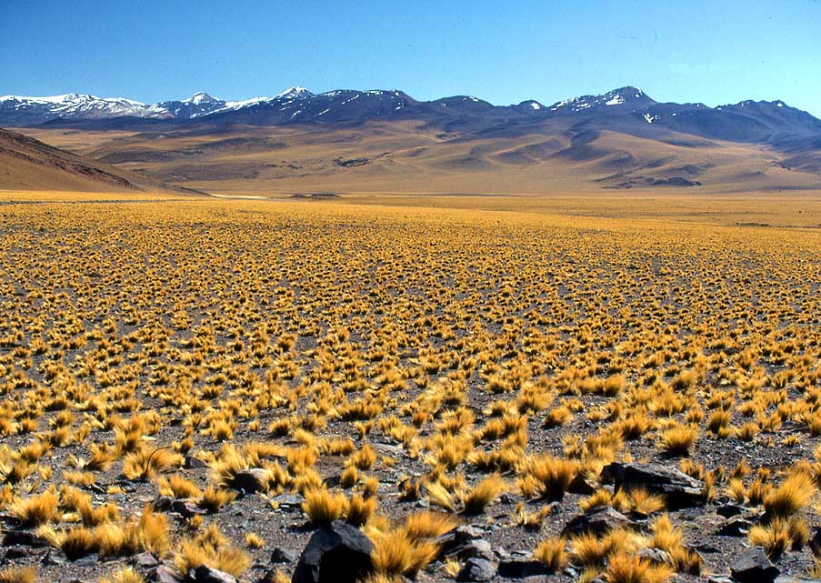
12th to April 10th, 2016
- Iran – April 11th to
May 6th, 2016
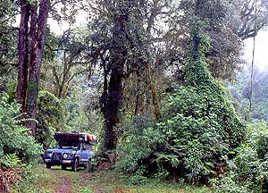
- Turkmenistan – May 6th to
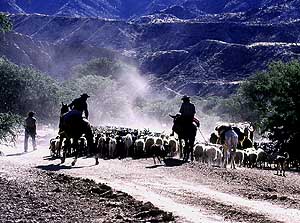
10th, 2016
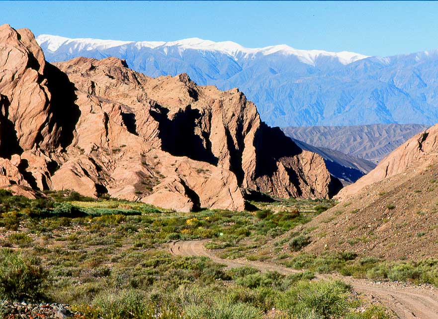
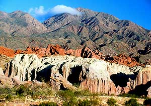
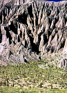
-
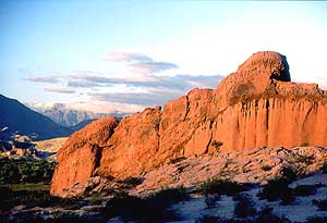
Uzbekistan – May 10th to
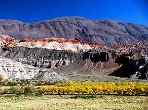
31st, 2016
-
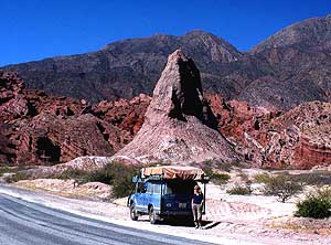
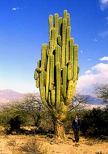
Tajikistan Part 1 – from
Uzbekistan border to Dushanbe û May 31st to June 18th, 2016
-
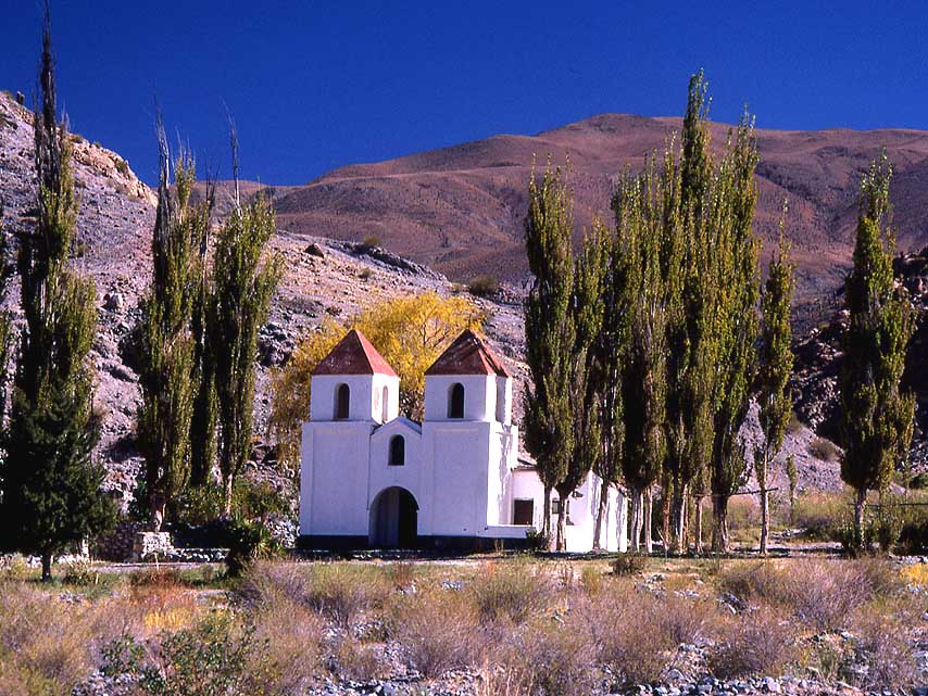
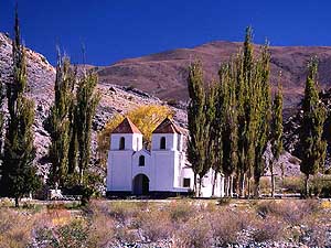
Tajikistan Part 2 – from
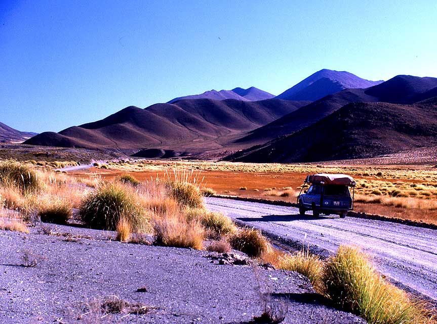
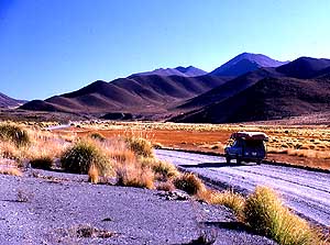
Dushanbe to the Kyrgyzstan border û June 19th to 27th, 2016
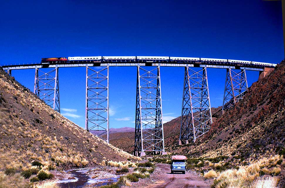
- Kyrgyzstan – June 27th to August 9th, 2016
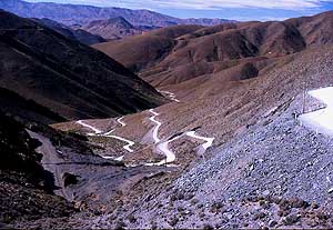
-
Kazakhstan û August 9th to 21st, 2016
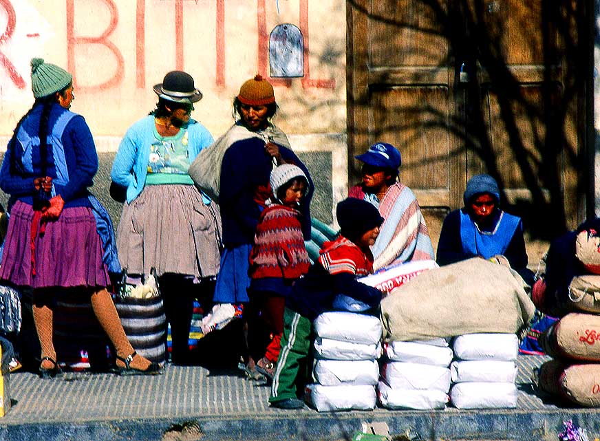
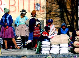
- Russia Part
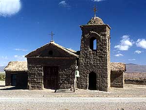
2a û from Tretyakovo at
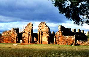
Kazakhstan border via Lake Teletskoye to Gorno Altaysk û August 21st to September
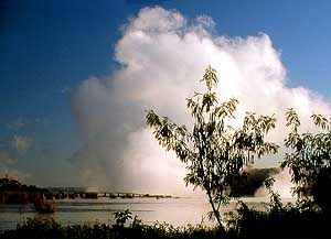
26th,
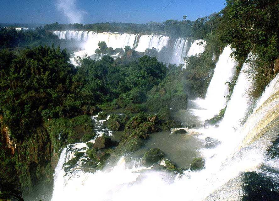
2016
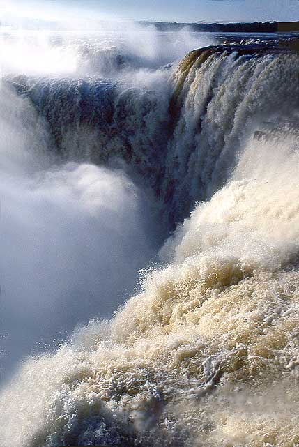
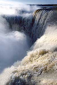
- Russia Part 2b – from
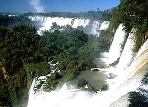
Gorno Altaysk to the Mongolia border and back to the Ukraine border at Krupets
û Sept. 26th to Nov. 11th, 2016
-
Ukraine Part 3 û November
11th to December 8th, 2016
- 3rd Rejuvenation of our
LandCruiser FJ60/1982 in
Miri/Sarawak/East
Malaysia from 2/6 to 5/3/2017
-
Sarawak-Kalimantan-North Sulawesi Part 1 û Miri
- Kuching/Sarawak/Malaysia -
Balikpapan/Kalimantan, by
ferry to Sulawesi
-
North-Sulawesi Part 2 û
Tomohon and surroundings to Tangkoko NP and onwards to Bitung with ferry
to Ternate on North Moluccas
-
North-Moluccas Part 1
û Ternate and Tidore and onwards by ferry to
Sofifi on Halmahera on North Moluccas
-
North-Moluccas Part 2
û Halmahera and onwards by ferry to Sorong in
West Papua Part 1 (Irian Jaya)
on western Bird's Head Peninsula
-
West Papua (Irian Jaya)
Part 1
û Sorong, éTrans Papua RoadÆ and onwards by
ferry to
Seram in Moluccas (Central)
-
Moluccas (Central) Part 1 û Seram and onwards by ferry
to
Ambon in Moluccas
-
Moluccas (Central)
Part 2 û Ambon and onwards by ferry
to Serui on Yapen in Papua
-
Papua
Part 1 û
Yapen and onwards by ferry
to Biak in Papua
-
Papua
Part 2 û
Biak and onwards by ferry
to Manokwari in West Papua
Part 2
(Irian Jaya) on eastern Bird's Head Peninsula
- West Papua
(Irian Jaya)
Part 2 û Manokwari,
éTrans Papua RoadÆ and onwards by ferry
to Makassar
in South Sulawesi
-
South Sulawesi-Kalimantan-Sarawak
Part 2 û Makassar
South Sulawesi by ferry to Batulicin/South Kalimantan, Kuching - Miri in Sarawak
- Continuation of
3rd Rejuvenation of our LandCruiser FJ60/1982 in Miri/Sarawak/East
Malaysia
from 7/16
to 9/22/2018
|